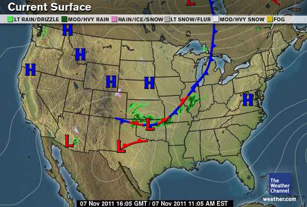
The above map is an image of the current weather in the United States...Using the information in Study Island, post a paragraph describing the current weather patterns in the US. (information for this can be found on page 3 of the lesson)

You must include the following in your response...
  • Describe what the H stands for and where (use state names) they are located on the map. (2.5 points)
  • Describe what the L stands for and where (use state names) they are located on the map. (2.5 points)
  • Tell what type of fronts are on the map and where they are located (2.5 points)
  • If there is any precipitation on the map, describe where and what it is. (2.5 points)
  • This post should be at least 5 sentences long (2.5 points) and written like a weather forecast that would appear on TV. (2.5 points)
A quality post will be detailed and should take 20-30 minutes to complete. 


Shawnda J.
11/7/2011 02:01:30 am

The H on the weather map stands for high pressure system. A high pressure system is when air is at a higher pressure then the air around it. The L on the weather map stands for low pressure system. A low pressure system is when the air pressure is lower then the air masses around it.The weather map shows that there will be warm fronts cold fronts and stationary fronts. There is going to be a warm front in Texas,a stationary front from New Mexico to Illinois,and a cold front from Illinois into Canada.

Reply
Anthony R.
11/7/2011 02:03:22 am

H stands for High Pressure System the are located over California, Nebraska, Wyoming, Montana and Virginia.
L stands for Low Pressure System the Ls is located Arizona, Texas. The types of fronts are cold fronts,stationary fronts and warm fronts.They're located in Texas, Oklahoma, Illinois, Michigan and Missouri.Their is precipitation a Lt.Drizzle rain its in Kansas, Illinois and Arizona.

Reply
joshua s
11/7/2011 02:19:55 am

the h stands for high pressure system
h-oregon,california,idaho,montana,wyoming,south dakota,nebraska,west virginia,virginia,washington

the l stands for low pressure system
arizona,texas,oklahoma

the stationary fronts are on-texas,oklahoma,

Reply
shayne
11/7/2011 02:19:58 am

#1.The H on the map stands for high pressure system and it is currently located at Wyoming,South Dakota,Nebraska,Montana,Oregon,California,West Virginia,Virginia,Idaho,and Washington.#2.The L on the map stands for Low pressure system New Mexico,Texas,Oklahoma,Missouri,Illinois and Michigan.

Reply
Jenna Carter
11/7/2011 02:58:04 am

The H on the map over northern CA, north eastern WA, south western MT, eastern WY, northern NA. and near Virginia mean there is high pressure in those areas.

The L located near western Arizona, southern Texas and Oklahoma mean that there is low pressure in those areas.

There is a cold front moving in from Canada, through Michigan and Illinois, and also through Missouri and Oklahoma. And kinda through Texas.

There's a stationary front through Illinois, Missouri, Oklahoma and Texas.

There's light rain in Arizona, heavy rain through Kansas and Oklahoma and Illinois.

Reply
Blake S.
11/7/2011 03:01:49 am

The capital H on the map stands for High Pressure System. Areas with high pressure systems on the map are Oregon, California,
Idaho, Montana, Wyoming, Virgina, West Virgina, and Maryland. The capital L on the map means Low Pressure System. Areas with low pressure systems are Texas, Oklahoma, and Arizona. The type of fronts their are on the map are Stationary, Cold, and Warm Fronts. They are located in Texas, Oklahoma, Missouri, Illinois, and Michigan. There is precipitation in Texas, Arizona, Oklahoma, Indiana, Kansas, Illinois, and
Missouri. Some of them are light rain and some of them are heavy rain.

Reply
Rashed B
11/7/2011 03:09:08 am

There are high pressure systems and there are low pressure systems. The H stand for A high pressure system in a local area of air that is at higher pressure than the air masses around it. there's a high pressure in northern California and southern Oregon and a High pressure in Wyoming. High pressure is also in the south part of south Dakota And north part of Iowa. A low pressure system is a local area of air that is at a lower pressure than air masses around it. Low pressure systems are often at the center of severe weather. There a low pressure system in Texas.Also there's a low pressure moving in to Oklahoma. And there a low pressure system in Arizona in the south side. There precipitation in Oklahoma there is a low pressure system with a cold front and a warm front.

Reply
Jordan J.
11/7/2011 03:12:02 am

The H represents a high pressure system going through Idaho, Montana,California, Wyoming, South Dakota, Nebraska, West Virginia, Virginia, and, Maryland.


Now,the L represents a low pressure system for Texas, Arizona, and Oklahoma.


Meanwhile,in New Mexico, Texas, Oklahoma, Missouri, and Illinois, there is a stationary front.


And a cold front located in Michigan.


Also very Light Drizzles in Northern Texas, South Arizona, also in Oklahoma, Kansas,Missouri, and Illinois.

Reply
kala B.
11/7/2011 03:18:18 am

The H stands for A high pressure system which is a located area of air that is at higher pressure than the air masses around it. The H is located in northern California,Idaho,Montana,Wyoming,Nebraska,West Virginia,Virginia,Maryland and DC.

The L stands for A low pressure system that is located in a area of air that is at a lower pressure than air masses around it. Low pressure systems are often at the center of severe weather.The is located in Arizona,Texas,Oklahoma,Canada.

The type of front that's on the map is
A stationary front this front occurs when a warm air mass has met a cold air mass and both air masses are at a standstill. The stationary front is located on Illinois,Missouri,Oklahoma an Texas.

The second front is the Cold Front this cold front occurs when a cold air mass moves in to meet an area of warm air. This front is located on Canada,Mitchigan,Illinois.

The third front is the warm front the Warm Front is a "boundary" that is created when a warm air mass moves in to meet an area of cold air.This front is located in Texas.

There is Precipitation on the map and it is located in Indania,Illinois,Missouri,Oklahoma,Kansas,Arizona an Washington.And Presipitation is rain.
Indania,Illinois,Missouri,Oklahoma,Kansas

Reply
Cody N
11/7/2011 03:23:15 am


The capital H on the map above is a high pressure system. The high pressure system is a area of air that is at higher pressure than the air masses around it. It is mostly common in the states California, Idaho, Montana, Wyoming, Nebraska, and Virginia.

The capital L on the map above is a Low pressure system. A low pressure system is a local area of air that is at a lower pressure than air masses around it. Low pressure systems are ussualy at the center of severe weather. It is common in the states Arizona, Texas, and Oklahoma.

There are three fronts on the map above they are stationary front, cold front, and warm front. The stationary front occurs when a warm air mass has met a cold air mass and both air masses which is located in the states Texas, Oklahoma, Missouri, and Illinois. The cold front is a boundary that is created when a cold air mass moves in to meet an area of warm air which is located in the states Illinois, and Michigan. The warm front is a boundary that is created when a warm air mass moves in to meet an area of cold air which is located in the state Texas.

Reply
jada b
11/7/2011 03:25:14 am

The H stands for high pressure system which means air that is at higher pressure than the air masses around it and this takes place in Idaho,Montana,California,Oregon,Wyoming,Nebraska,and around the Virgina area.The L stands for low pressure system which means air that is at lower pressure than air masses around it and this takes place in Arizona,Texas,and Oklahoma.There are stationary fronts which occurs when warm air mass has meet cold air mass and both air masses are at a standstill and this is occuring in Texas,Oklahoma,Missouri,and Michigan.There are also warm fronts which is a boundary which is created when a warm air mass moves in and meets a cold air mass and this is occuring in Texas.There are also cold front which is a boundary that is created when cold air moves in to meet warm air and this is occuring in Michigan.I think it will rain in Michigan.

Reply
Izzy S
11/7/2011 03:51:43 am

The H on the map stands for High Pressure System . On the map , they are located in Oregon and California , Idaho , Montana , Wyoming , South Dakota , Nebraska , and Virginia .
The L on the map stands for Low Pressure System . On the map it is in Texas , Oklahoma , and Arizona .
There is a Warm Front in Texas , Cold Front in Michigan , and Stationary Front in Texas , Oklahoma , Missouri , and Illinois .
There's precipitation predicted for Oklahoma , Kansas , upper Texas , Missouri , Illinois , and a little in Arizona and Washington .

Reply
david b
11/7/2011 03:53:56 am

The big H means high pressure system a located at California,Idaho,Montana,Colorado,Nebraska, Virgina and west Virgina.
The big L means LOW Pressure system an there located at Texas and new Mexico.

A warm front is located in new Mexico and Texas. The stationary front in located at Oklahoma,Missouri, an in Illinois.And the cold front is located on Illinois and Michigan.

Precipitation is located in new Mexico, Oklahoma,Missouri, Illinois, and Kansas.

Reply
Tricia B.
11/7/2011 04:00:51 am

The H stands High pressure system. The high pressure system are located at California, Oregon, Idaho, Montana, Wyoming, South Dakota, Nebraska, West Virgina, Virgina. The L stands for Low pressure system. The Low pressure system are located at Oklahoma, Arizona, Texas, and New Mexico. The fronts are lactated at Michigan, Illinois, Missouri, Oklahoma, Texas. There will be heavy and light rain in Kansas, Texas, Arizona, Oklahoma.

Reply
Max D.
11/7/2011 04:03:55 am

The H stands for high pressure. The high pressure signs are located over California, halfway in between Canada and Idaho, Montana, Wyoming, Nebraska, and Virginia on the map. The L sign stands for low presser. The Low presser signs are located over Arizona, Texas,and Oklahoma. There is also a stationary front cutting threw the west. There is some rain over Illinois, Missouri, and Kansas.

Reply
kayla L
11/7/2011 04:08:16 am

The H on the map stands for high pressure. The H's on the nap are over California,Idaho,Montana,Wyoming,South Dakota,Nebraska,West Virginia,Virginia. The L on the map stands for low pressure. The L's on the map are in Arizona,Texas and,Oklahoma.The types of fronts on the map are warm front, cold front, Stationary front. The warm front is over Texas. The cold front is over Illinois and Michigan. The Stationary front is over Texas, Oklahoma,Missouri Illinois. There is some precipitation and its over Oklahoma, Missouri, and Illinois.

Reply
Jordan B.
11/7/2011 04:11:41 am

The H's stand for high pressure. Then place's where there is high pressure are California, Idaho, Montana, Wyoming, Nebraska, Virginia. The L's on the map stand for low pressure. The states that have low pressure are Arizona, Oklahoma and Texas.

There is a cold front going through about three of the eastern states. There is a stationary front going through some southern states. Between New Mexico and Texas there is a warm front.

Most of the precipitation is over Oklahoma and Kansas.

Reply
J.A
11/7/2011 04:12:37 am

The H stands for high pressure and the states that has High Pressure are located on is Virginia area,Nebraska,South Dakota,Wyoming,Montana in between California and Oregon and on the top of Idaho Montana and Washington.

The L stands for Low Pressure and the states That has Low Pressure are located on Oklahoma,Arizona and on Texas.

The red and blue lines you see on the map are warm and cold fronts and There is a warm front on Texas and a warm and cold front running between the mid west.

Most of this precipitation is located in Oklahoma and Kansas.

Reply
Jade B
11/7/2011 04:16:43 am

H stands for high pressure and they are located... California,Idaho,Wyoming,Nebraska and Virginia.
L stands for low pressure and they are located... Arizona,Texas and
Oklahoma.
there is a warm front in Texas,there is a cold warm front in Oklahoma,Missouri,Illinois and there is a cold front in Michigan.oklahoma and kannas
most of the precipitation are in

Reply
Anthony.K
11/7/2011 10:49:43 pm

the H stand's for high pressure and can be found over, California, Idaho and Montana, Nebraska, and new jersey. But the L stand's for low pressu

Reply
Emma S
11/15/2011 11:33:39 pm

The H means high pressure it's located around the California, and the Montana area. Technically all around the East side. The L means Low pressure and it's located Texas, New Mexico and Kentucky. The front is a stationary front.

Reply

Your comment will be posted after it is approved.


Leave a Reply.