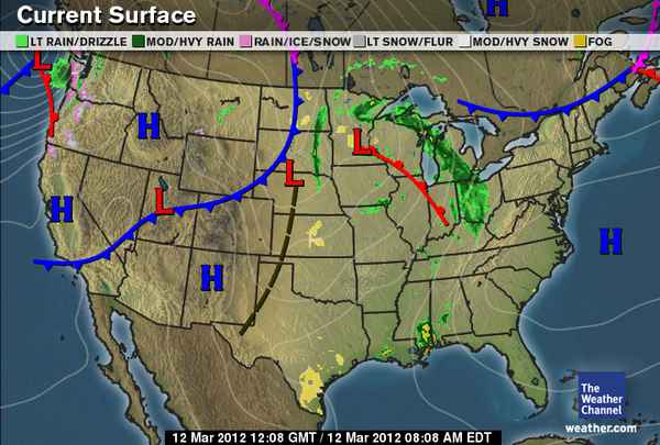
The above map is an image of the current weather in the United States...Using the information in Study Island, post a paragraph describing the current weather patterns in the US. (information for this can be found on page 3 of the lesson)

You must include the following in your response...
  • Describe what the H stands for and where (use state names) they are located on the map. (2.5 points)
  • Describe what the L stands for and where (use state names) they are located on the map. (2.5 points)
  • Tell what type of fronts are on the map and where they are located (2.5 points)
  • If there is any precipitation on the map, describe where and what it is. (2.5 points)
  • This post should be at least 5 sentences long (2.5 points) and written like a weather forecast that would appear on TV. (2.5 points)
A quality post will be detailed and should take 20-30 minutes to complete.
Logan W
3/11/2012 10:04:43 pm

For today`s weather the H stands for High pressure in Idaho, California, New mexico. There are Low pressure in South Dakota, Nebraska, Minnesota. There are cold fronts in the south and warm fronts in the north. there is precipitation in Ohio and in Michigan. That is today's weather.

Reply
3/11/2012 10:04:58 pm

There is a High Pressure system in California, Arizona, and Idaho so the weather will most likely be warm. There is a cold front in Utah, Nebraska and Minnesota. So the weather should be pretty cold. There is also a cold front located in the North and in the Northwest. So get your jackets on. There is a warm front in the northern states such as Indiana and Illinois. An for a last there is light and heavy rainfall in the North with a little bit of rain/snow in the Northwest such as Washington. Thank you for listening to your local forecast. An we're out.

Reply
Amber Packy
3/11/2012 10:06:54 pm

The H stands for a high pressure system is a local area of air that is at higher pressure than the air masses around it.The H is on the following states:Idaho,California,New Mexico,and Pacific Ocean.

The L stands for a low pressure system is a local area of air that is at a lower pressure than air masses around it. Low pressure systems are often at the center of severe weather.The L is on the following states:Utah,Iowa,South Dakota,Atlantic Ocean.

The type of fronts on the map are warm front and the cold front.The warm fronts are located in South Dakota,Illinois,Iowa,and the Atlantic Ocean.The warm fronts are located in California,Nevada,Utah,and Wyoming.

There is precipitation on the map located in Ohio,Michigan,and Wisconsin.


Reply
DezJanah Harper
3/11/2012 10:11:33 pm

The H stands for high pressure system and it is located over California, New Mexico,and Idaho.the L stands for low pressure system and it is located in Minnesota Utah,and Nebraska.The fronts that are located on the map is cold fronts and warm fronts.The precipitation that is on the map is fog and rain. they are located in Texas,Ohio,Michigan,Wisconsin,Louisiana,Mississippi,North Dakota,South Dakota,Kansas,Missouri,and Montana.

Reply
Deair Wade
3/11/2012 10:14:29 pm

1.The H stands for High pressure system.

2.The L stands for low pressure.

3.There are Cold fronts and Warm fronts and they are located on California,Idaho,New Mexico,Utah,Minnesota,and Nebraska.

4.There is rain and it is through Minnesota,Wisconsin,Michigan,and Ohio.


Reply
Raicharr Wray- Johnson
3/11/2012 10:15:49 pm

The Raicharr Forecast

For today's forecast we are gonna be talking about what the (H) stands for that appears on all of the following states California, New Mexico, Idaho, and it also appears on the Pacific Ocean. This (H) stands for A high pressure system. A high Pressure system is where it is hot.

Next is the Lower Pressure System (L) . This L is where the weather is not so hot. This weather appears in the following states,Utah,Nebraska, Minnesota, and it also appears in the Pacific Ocean too.

There are 2 kind of Fronts on this map which are called a Warm Front and a Cold Front. The Warm Fronts appear in the Pacific Ocean, Minnesota, Wisconsin, Illinois, Indiana, and Oregon. A Warm Front is a "boundary" that is created when a warm air mass moves in to meet an area of cold air. The Cold Fronts appear in the following states and Oceans, Pacific Ocean, California,Nevada, Utah, Colorado, Wyoming,Nebraska South Dakota, North Dakota,Maine, New Hampshire, New York, and Vermont. A Cold Front is a boundary" that is created when a cold air mass moves in to meet an area of warm air.

The precipitation is that there will be rain coming later in the day.
Also there will be Ice/Snow . Also there will be some showings of fog later.


THANKS FOR WATCHING Raicharr's Forecast...........

Reply
Raicharr Wray- Johnson
3/11/2012 10:16:31 pm

The Raicharr Forecast

For today's forecast we are gonna be talking about what the (H) stands for that appears on all of the following states California, New Mexico, Idaho, and it also appears on the Pacific Ocean. This (H) stands for A high pressure system. A high Pressure system is where it is hot.

Next is the Lower Pressure System (L) . This L is where the weather is not so hot. This weather appears in the following states,Utah,Nebraska, Minnesota, and it also appears in the Pacific Ocean too.

There are 2 kind of Fronts on this map which are called a Warm Front and a Cold Front. The Warm Fronts appear in the Pacific Ocean, Minnesota, Wisconsin, Illinois, Indiana, and Oregon. A Warm Front is a "boundary" that is created when a warm air mass moves in to meet an area of cold air. The Cold Fronts appear in the following states and Oceans, Pacific Ocean, California,Nevada, Utah, Colorado, Wyoming,Nebraska South Dakota, North Dakota,Maine, New Hampshire, New York, and Vermont. A Cold Front is a boundary" that is created when a cold air mass moves in to meet an area of warm air.

The precipitation is that there will be rain coming later in the day.
Also there will be Ice/Snow . Also there will be some showings of fog later.


THANKS FOR WATCHING Raicharr's Forecast.

Reply
Tyler.D
3/11/2012 10:23:21 pm

H stands for High pressure systems ,high pressures is a local area of air that masses around the air .High pressure is found an many places or states that are hot such as,Atlanta,GA and Manchester ,NH some are located an places that we never knew would be located at,high pressures is mainly located down south . Low pressure is a low pressure of system that surrounds around to but an a different way A low pressure system is a local area of air that is at a lower pressure than air masses around it. Low pressure are often around .........are state Ohio mainly an Youngstown low pressure is mainly around the north because hoe cold it is and how down it is

Reply
Niya M.
3/11/2012 10:28:32 pm

There is a high pressure system in California, Idaho, New Mexico and Canada.
A high pressure system is a local area of air that is at higher pressure than the air masses around it.

There is a low pressure system sin Minneota, Utah, North Dakota and South Dakota.
A low pressure system is a local area of air that is at a lower pressure than air masses around it. Low pressure systems are often at the center of severe weather

There is also a cold front going through California, Nevada, Utah, Wyoming, Colorado, Nebraska, North Dakota and South Dakota. And there is also going to be a warm front going through Indiana, Illinois, Wisconsin, and Minnesota. And there is also a trough going through Texas, Oklahoma, Kansas and Nebraska.

There is also precipitation in Ohio and Michigan which means heavy rain so carry you're unbrella.


Reply
RickyD
3/11/2012 10:53:29 pm

The H stands for high pressure system and their in New Mexico,Idaho,and California.The L stands for low pressure system and their in Utah,Minnesota,and Nebraska.There are cold fronts through California to North Dakota,there are warm fronts through Minnesota to Indiana,and troughs from Texas to Nebraska.There is heavy rain from Ohio to Minnesota and from North Dakota to South Dakota.

Reply
Reno S.
3/11/2012 10:57:23 pm

H is a High pressure system
A high pressure system is a local area of air that is at higher pressure than the air masses around it.

L is a Low pressure system
A low pressure system is a local area of air that is at a lower pressure than air masses around it.

There are three high pressure system located near the west ( California, Idaho , New Mexico)
There are two low fronts located in Utah, Nebraska, and Minnesota.

There is a cold front going through the west region, and a warm front going through Ohio, and a Trough from Texas to Nebraska.

Reply
Kathrine E.
3/11/2012 10:59:10 pm

The H stands for High pressure system.A high pressure system is a local area of air that is at higher pressure than the air masses around it.The H is in the states of Idaho,California,and New Mexico.The L stands for low pressure system.The L is in the states of Utah,Nebraska,South Dakota and Minnesota.A low pressure system is a local area of air that is at a lower pressure than air masses around it. Low pressure systems are often at the center of severe weather.The type of fronts on the map are Cold front and Warm front.The warm front is located in the states of Minnesota,Wisconsin,Iowa,and Illinois.The cold front is located in the states of California,Nevada,Utah,Wyoming,and Nebraska.

Reply
Kaytlyn T .
3/11/2012 11:01:44 pm

In California and Idaho and New Mexico there is a High Pressure System . In Utah, Nebraska , Kansas and Minnesota there's a Low Pressure System. There is a warm and cold front front there is a warm front in Indiana and there is a cold front in North and South Dakota . The is precipitation in the East by Ohio .

Reply
Reno S.
3/11/2012 11:02:01 pm

(Part 2) There is precipitation in the mid east near Ohio and Michigan and more precipitation west in Washington.

Reply
Jordan P.
3/11/2012 11:02:50 pm

High pressure system in Idaho,California and New Mexico.
Low pressure system in Utah,Nebraska and Minnesota.
Warm fronts though Indianan, Illinois, Wisconsin and Minnesota.
Cold fronts though California,Nevada,Utah,Colorado,Wyoming, Nebraska,South Dakota and North Dakota.
Precipitation in east,west,north and south.

Reply
dakota s.
3/11/2012 11:09:41 pm

there are high pressure systems (H) located in Idaho,California,New Mexico, and in the Atlantic ocean .Located in Utah,Nebraska,and Minnesota are low pressure systems (L),In the north west there is a warm front coming into Washington and Oregon, another warm front in the mid east,cold front in the midwest and southwest and a cold front in the northeast. there is precipitation spreading through Ohio, Michigan ,and Wisconsin.

Reply
Tesha S.
3/11/2012 11:58:16 pm

Weather patterns in the U.S. normally move from west to east. The H stands for high pressure system which means that the air in the local are is higher than the air surounding it. The high pressure system on the map is located in New Mexico,California,and Idaho. The L stands for low pressure system which means that the local air is colder than the surrounding air. The low pressure system on the map is located in Minnesota, Utah and North and South Dakota. There are occluded, warm and cold fronts on the map. They are located in California, Nevada, Utah, Wyoming, South and North Dakota, Indiana, Wisconsin, and Canada. There is some precipitation on the map it is near Ohio and Indiana and it reaches up to Canada.

Reply
Miguel.A
3/12/2012 12:12:01 am

A high pressure system is a local region of air that is at a higher pressure than air masses around it. It is labeled on a weather map with a capital H. High pressure systems tend to be made up of cooler air. Air tends to diverge, or spread out from high pressure systems
A low pressure system is a local region of air that is at a lower pressure than air masses around it. It is labeled on a weather map with a capital L. Low pressure systems tend to be made up of warmer air. Air tends to converge toward, or move into low pressure systems. Low pressure systems are often at the center of severe weather.
-On the map the H are idaho,cail,&new mexico and the L are Utah, south detkota,nebrassica,wesiosion

Reply
Devionne.B
3/12/2012 12:20:50 am

the H stands for a high pressure in Idaho the L stands for low pressure in Utah it is percipation on the on the west side of Illinois cold fronts on the east side of the map

Reply
logan bates
3/12/2012 12:22:40 am

The H stands for the high pressure system.
the states that have the H are idaho,california. oregon.
the L stands for the low pressure system.
the state names are, wyhoming, nebraska, and minnesota. there is heavy rain. there is some drizzle. there is some fog. there is rain/ice/snow. the heavy rain is located in

Reply
Shianne P. (:
3/12/2012 12:29:17 am

The "H" that stands for high weather, is located in the states of California, Idaho, and New Mexico. It usually means it is hotter there then in other states.
The "L" which means the temperature is low, or colder, is in Utah, Minnesota, South Dakota, Nebraska, and towards Alaska.
There is a trough front going from Nebraska to Texas. It means there is low pressure there.
There are cold fronts in the west and north east along with warm fronts in Wisconsin through Indiana and one outside of Oregon.
There is rain in the north east, along with scattered fog around Texas, Kansas, and Minnesota...

Reply
Trisha Wishart
3/12/2012 12:29:55 am

The "H" stands for High pressure system, which is located in Idaho, California, New Mexico.
The "L" stands for Low pressure system, which is located in Illinois, Nabraska, and Utah.
There are cold fronts and warm fronts that are located in Nabraska to Indiana. And the cold fronts are located from California to Candia.

Reply
Autumn S.
3/12/2012 12:30:32 am

The ''H'' Stand For High Pressure System And Its Located In Idaho , California , New Mexico
The "L" Stand For Low Pressure System And Its Located In Minnesota , Nebraska , And Utah.
Its Cold Fronts , Warm Fronts , And Occluded Fronts. The Cold Front Is In California , Utah , Colorado , Nebraska , South Dakota , North Dakota. The Warm Fronts Are In Minnesota , Indian , Illinois , Wisconsin. The Occluded Is Located In Canada.

Reply
alyssa
3/12/2012 12:30:37 am

today the weather is very windy and cold out and a slight chance of rain or snow.The H stands for high pressure in new mexico,california,and idaho.The L stands for low pressure in Nebraska,and Utah.Theres alot of precipitation in all statesThose are located on the map because it shows the light rain,heavy rain,ice,snow,light snow,heavy snow,and fog that is occuring in each one of those states and it shows how much precipitation is hapening in each one of those states.Theres precipitation on the map located at point L and point H.And if you look on the map its going kinda passed Minnesota.So be careful and watch out for that weather,lot of precipitation.

Reply

Your comment will be posted after it is approved.


Leave a Reply.